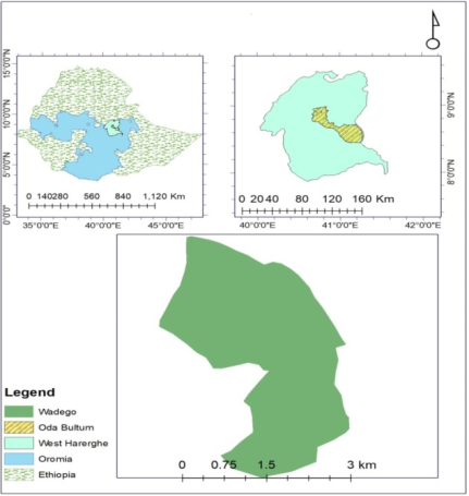
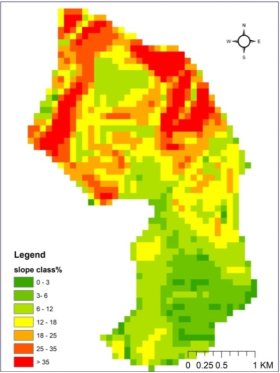
Baseline characterization is important component of watershed development of rural development and natural resource management strategies in many countries. Hence, the study was designed to; assess and document major biophysical and socio-economic constraints and potentials of Wadego watershed. Firstly, Wadego watershed boundary was delineated and its map was developed based on the preliminary outlet identified with the help of GPS reading. The households for interview were selected randomly from the small householders in the watershed based on proportional to population size. Accordingly, data was collected from 120 sample respondents using various instruments such as: key informant interview using semi-structured checklist, focused group discussion, expert interview, unstructured questionnaire and field observation on bio-physical resources and different concerns of watershed management. Collected data was summarized using descriptive statistics. The result indicated, out of the total 120 sample respondents socio-economic status were; 87.5% of them were male while the rest 12.5% were female, 93% were married, 51% were un educated. The major crops grown in the watershed were Maize, Sorghum, Khat, Teff and others while, Barley and Field Pea were the least grown ones. The result of the survey has indicated 37% uses improved variety, while 64% uses local variety. According to respondents, the slop class of the watershed was 56, 29, and 15% flat, medium and steeply slops respectively. Moreover, soil fertility class was 25%, 54% and 21% low, medium and high respectively in the watershed. Generally, the survey result have characterized and documented bio-physical and socio-economic status as: average land owned half hectare, densely populated, different slope class in the watershed, land shortage, feed problems, presence of soil fertility and erosion problems, climatic problems etc. in the watershed. Accordingly, researchable issues on different prioritized problems concerning to; soil fertility management, soil and water conservation, Agroforestry practice, forage development and forestry practices in the watershed have given prioritization and therefore, adapted and generated technologies nearby research center i.e. Mechara Agricultural Research Center and any concerned research institutions and also development work oriented NGO’S has to intervened the watershed by research development work. Accordingly, intervention areas forwarded are: Creating awareness on climate variability and change and SWC techniques, introducing different biophysical soil and water harvesting technologies, demonstration and awareness creation, Participatory demonstration on different Agroforestry and plantation forestry practices, introducing multipurpose plant species like Bamboo variety in the watershed.
| Published in | Journal of Energy and Natural Resources (Volume 13, Issue 3) |
| DOI | 10.11648/j.jenr.20241303.11 |
| Page(s) | 114-124 |
| Creative Commons |
This is an Open Access article, distributed under the terms of the Creative Commons Attribution 4.0 International License (http://creativecommons.org/licenses/by/4.0/), which permits unrestricted use, distribution and reproduction in any medium or format, provided the original work is properly cited. |
| Copyright |
Copyright © The Author(s), 2024. Published by Science Publishing Group |
Constraints, Potentials, Wadego Watershad, Watershed Management
Slope class | Description |
|---|---|
0-3 | Nearly level |
3-6 | Gently sloping |
6-12 | Moderately slopping |
12-18 | Strongly slopping |
18-25 | Moderately steep |
25-35 | steep |
>35 | Very steep |
Characteristics | Frequency (#) | Percentage (%) | |
|---|---|---|---|
Sex | Male | 105 | 87.5 |
Female | 15 | 12.5 | |
Marital status | Married | 112 | 93 |
Single | 8 | 7 | |
Education level | Uneducated | 61 | 51 |
Informal education | 25 | 21 | |
Grade 1-8 | 21 | 18 | |
Grade > 9 | 13 | 11 |
S.N. | crops | frequency | % growers |
|---|---|---|---|
1 | Maize | 21 | 18 |
2 | Sorghum | 15 | 13 |
3 | Khat | 13 | 11 |
4 | Teff | 12 | 10 |
5 | Chick pea | 11 | 9 |
6 | Coffee | 10 | 8 |
7 | Common bean | 9 | 8 |
8 | Mango | 9 | 7 |
9 | Tomato | 8 | 6 |
10 | Banana | 5 | 4 |
11 | Field Pea | 3 | 3 |
12 | Barley | 3 | 3 |
Total | 120 | 100 |
S.N. | Tools | Frequency | % of holders |
|---|---|---|---|
1 | Corrugated roof house | 15 | 12 |
2 | Solar power | 14 | 12 |
3 | Spade | 13 | 11 |
4 | Hoe (Gasoo) | 13 | 11 |
5 | Axe ( qottoo) | 12 | 10 |
6 | Machete (Mencaa) | 12 | 10 |
7 | Slashes | 11 | 9 |
8 | Mobile phone | 9 | 8 |
9 | Knapsack spray | 8 | 7 |
10 | Radio(Functional) | 7 | 6 |
11 | Hat roof house | 5 | 4 |
12 | Water pump | 1 | 1 |
Total | 120 | 100 |
NPS | UREA (kg) | Compost | FYM (kg) | Lime (kg) | Herbicide (l) | Insecticide (l) | Fungicide (l) | |
|---|---|---|---|---|---|---|---|---|
Conventional (kg) | Vermin compost (kg) | |||||||
25 | 25 | 1000 | 0 | 1300 | 0 | 1 | 1 | 2 |
S.N. | crop | frequency# | % of farmers sale |
|---|---|---|---|
1 | Khat | 67 | 56 |
2 | Tomato | 18 | 15 |
3 | Chickpea | 11 | 9 |
4 | Common bean | 8 | 7 |
5 | Maize | 6 | 5 |
6 | Coffee | 10 | 8 |
Total | 120 | 100 |
S.N. | Conservation measure used | frequency(#) | % of farmers practice it |
|---|---|---|---|
1 | Soil bund | 30 | 25 |
2 | Water way | 30 | 25 |
3 | Cut off drain | 27 | 23 |
4 | Terrace | 15 | 12 |
5 | Stone bund | 10 | 8 |
6 | Soil bund and Stone bund | 6 | 5 |
7 | Fanya Juu | 2 | 2 |
Total | 120 | 100 |
Biological Conservation measure used | frequency(#) | % of farmers practice it |
|---|---|---|
Road side planting | 12 | 10 |
Farm boundary | 19 | 16 |
Hedge row/Khat | 89 | 74 |
Total | 120 | 100 |
livestock | frequency# | % of farmers owned |
|---|---|---|
Local cow | 24 | 20 |
Ox | 13 | 11 |
Local Bulls | 13 | 11 |
Cross breed bulls | 0 | 0 |
Local Heifers | 7 | 6 |
Cross breed Heifers | 0 | 0 |
Calves | 11 | 9 |
Sheep | 4 | 3 |
Goats | 14 | 11 |
Horse | 0 | 0 |
Mule | 0 | 0 |
Donkey | 14 | 11 |
Local Chicken | 12 | 10 |
Exotic Chicken | 2 | 2 |
Traditional honey bees hive with colony | 5 | 5 |
Modern honey hive bees with colony | 1 | 1 |
Total | 120 | 100 |
S. No. | Feed type | Frequency# | % of farmers used |
|---|---|---|---|
1 | Crop residues | 30 | 25 |
2 | Improved forages/fodder | 26 | 22 |
3 | Green feed (cut & carry) | 21 | 17 |
4 | Concentrates of different types (Nug cake) | 18 | 15 |
5 | Stubble grazing | 11 | 9 |
6 | Hay making | 9 | 8 |
7 | Grazing in the field | 5 | 4 |
Total | 120 | 100 |
constraints | Frequency# | % of respondent |
|---|---|---|
Land shortage | 12 | 10 |
Agricultural inputs (time, price, quantity supply) | 11 | 9.2 |
Soil fertility | 11 | 9.2 |
Grazing system | 10 | 8.3 |
Feed and fodder | 10 | 8.3 |
Soil erosion | 10 | 8.3 |
Inflation | 10 | 8.3 |
Crop disease | 10 | 8.3 |
Employment opportunity | 9 | 7.5 |
Climate change (temperature, rain fall, drought, etc) | 9 | 7.5 |
Storage pests | 9 | 7.5 |
Electricity | 9 | 7.5 |
Total | 120 | 100 |
S. N. | opportunities | Frequency # | % of respondent |
|---|---|---|---|
1 | Availability of labor force | 11 | 9.2 |
2 | Informal institutions (Dabo, Ikub and etc) | 9 | 7.5 |
3 | Suitable agro ecology | 9 | 7.5 |
4 | Schools | 9 | 7.5 |
5 | Farmers cooperatives | 8 | 6.7 |
6 | Health center | 8 | 6.7 |
7 | Forest | 7 | 5.8 |
8 | Permanent river | 7 | 5.8 |
9 | Saving and credit institutions | 9 | 7.5 |
10 | markets access | 6 | 5.0 |
11 | Livestock clinic | 6 | 5.0 |
12 | All weather road | 5 | 4.2 |
13 | Transport service | 5 | 4.2 |
14 | Drinking water | 5 | 4.2 |
15 | Youth and women associations | 4 | 3.3 |
16 | Artificial lakes | 4 | 3.3 |
17 | Source of seed | 4 | 3.3 |
18 | Electricity | 4 | 3.3 |
Total | 120 | 100 |
NGO | Non-Government Organization |
CALM4R | Climate Action Through Landscape Management Program for Result |
SWC | Soil and Water Conservation |
| [1] | Abbaspour, K. C., Rouholahnejad, E., Vaghefi S. R. I. N. I. V. A. S. A. N. B., Srinivasan R., Yang H. & Kløve B. (2015). A continental-scale hydrology and water quality model for Europe: Calibration and uncertainty of a high-resolution largescale SWAT model. Journal of Hydrology, 524, pp. 733-752. |
| [2] | Yamane, T. Statistics: An Introductory Analysis, Harper and Row, New York, NY, USA, 2nd edition, 1967. |
| [3] | Anantha, K. H., Suhas P. W., & Sreedevi T. K. (2009). Baseline Socio-economic Characterization of Watersheds; International Crops Research Institute for the Semi-Arid Tropics (ICRISAT) Patancheru 502 324, Andhra Pradesh, India. |
| [4] | Brooks, N. K., Folliot P. F., & Thames J. L. (1991). Watershed Management: A Global Perspective, Hydrology and the Management of Watersheds. Ames, Iowa: Iowa State University Press pp 1-7. |
| [5] | Admassu, Z., Gizaw, A., Alemu, G., Mekonnen, K., Gebremikael, M. T., Amede, T. & German, L. (2008). Watershed-based soil and water conservation experiences in Ethiopian highlands. In Working with communities on integrated natural resources management (pp. 27-39). Ethiopian Institute of Agricultural Research (EIAR). |
| [6] | Blackburn, J. & Holland J. (eds.). (1998). Who Changes? Institutionalising Participation in development. London: Intermediate Technology Publication Ltd. |
| [7] | Gebregziabher, G., Abera, D. A., Gebresamuel, G., Giordano, M. & Langan, S. (2016). An assessment of integrated watershed management in Ethiopia (Vol. 170). International Water Management Institute (IWMI). |
| [8] | Zenebe A. (2005). The Impact of Land tenure Systems on Soil and Water Conservation Practices in Berissa Watershed, Ethiopia. MSc Thesis, Wageningen University and Research center, The Netherlands. Pp 107. |
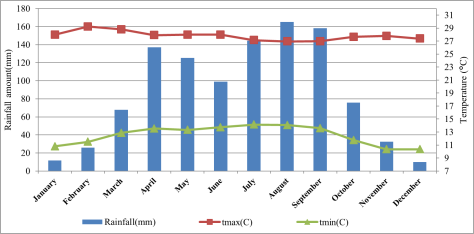
| [9] | Wasihun Gizaw, 2021. Historical Rainfall Amount and Temperature Variability and Trend in West Harerhge Zone, East Ethiopia. Mechara Agricultural Research Center. |
| [10] | Y. S. Kebede, N. T. Endalamaw, B. G. Sinshaw, and H. B. Atinkut, “Modeling soil erosion using RUSLE and GIS at watershed level in the upper Beles, Ethiopia,” Environmental Challenges, vol. 2, Article ID 100009, 2021. |
| [11] | M. Sartori, G. Philippidis, E. Ferrari et al., “A linkage between the biophysical and the economic: assessing the global market impacts of soil erosion,” Land Use Policy, vol. 86, pp. 299-312, 2019. |
| [12] | M. Belayneh, T. Yirgu, and D. Tsegaye, “Runoff and soil loss responses of cultivated land managed with graded soil bunds of different ages in the upper blue Nile basin, Ethiopia,” Ecological Processes, vol. 9, no. 1, pp. 66-18, 2020. |
| [13] | E. Nkonya, T. Johnson, H. Y. Kwon, and E. Kato, “Economics of land degradation in sub-Saharan Africa,” in Economics of Land Degradation and Improvement-A Global Assessment for Sustainable Development, pp. 215-259, Springer, Berlin, German, 2016. |
| [14] | T. Fayera, “Assessment of the effectiveness biophysical soil and water conservation structures: a case study of kiramuworeda, east Wollega zone, Ethiopia,” Applied Research in Science and Technology, vol. 1, no. 2, 2021. |
| [15] | L. Bou-Imajjane and M. A. Belfoul, “Soil loss assessment in western high atlas of Morocco: beni mohand watershed study case,” Applied and Environmental Soil Science, vol. 2020, no. 143, Article ID 6384176, 15 pages, 2020. |
| [16] | A. Amsalu and J. De Graaff, “Determinants of adoption and continued use of stone terraces for soil and water conservation in an Ethiopian highland watershed,” Ecological Economics, vol. 61, no. 2-3, pp. 294-302, 2007. |
| [17] | A. D. Atnafe, H. M. Ahmed, and D. M. Adane, “Determinants of adopting techniques of soil and water conservation in Goromti watershed, eestern Ethiopia,” Journal of Soil Science and Environmental Management, vol. 6, no. 6, pp. 168-177, 2015. |
| [18] | M. Belayneh, T. Yirgu, and D. Tsegaye, “Effects of soil and water conservation practices on soil physicochemical properties in Gumara watershed, upper blue Nile basin, Ethiopia,” Ecological processes, vol. 8, no. 1, pp. 36-14, 2019. |
| [19] | M. Sileshi, R. Kadigi, K. Mutabazi, and S. Sieber, “Determinants for adoption of physical soil and water conservation measures by smallholder farmers in Ethiopia,” International soil and water conservation research, vol. 7, no. 4, pp. 354-361, 2019. |
| [20] | T. Tanto and F. Laekemariam, “Impacts of soil and water conservation practices on soil property and wheat productivity in Southern Ethiopia,” Environmental Systems Research, vol. 8, no. 1, pp. 13-19, 2019. |
| [21] | B. Tefera and G. Sterk, “Land management, erosion problems and soil and water conservation in Fincha’a watershed, western Ethiopia,” Land Use Policy, vol. 27, no. 4, pp. 1027-1037, 2010. |
| [22] | K. Wolka, “Effect of soil and water conservation measures and challenges for its adoption: Ethiopia in focus,” Journal of Environmental science and Technology, vol. 7, no. 4, pp. 185-199, 2014. |
APA Style
Gizaw, W., Dekeba, S. (2024). Socio-economic and Bio-physical Characterization of Wadego Watershed, Oda-Bultum Woreda, West Hararghe zone, Ethiopia. Journal of Energy and Natural Resources, 13(3), 114-124. https://doi.org/10.11648/j.jenr.20241303.11
ACS Style
Gizaw, W.; Dekeba, S. Socio-economic and Bio-physical Characterization of Wadego Watershed, Oda-Bultum Woreda, West Hararghe zone, Ethiopia. J. Energy Nat. Resour. 2024, 13(3), 114-124. doi: 10.11648/j.jenr.20241303.11
AMA Style
Gizaw W, Dekeba S. Socio-economic and Bio-physical Characterization of Wadego Watershed, Oda-Bultum Woreda, West Hararghe zone, Ethiopia. J Energy Nat Resour. 2024;13(3):114-124. doi: 10.11648/j.jenr.20241303.11
@article{10.11648/j.jenr.20241303.11,
  author = {Wasihun Gizaw and Shimelis Dekeba},
  title = {Socio-economic and Bio-physical Characterization of Wadego Watershed, Oda-Bultum Woreda, West Hararghe zone, Ethiopia
},
  journal = {Journal of Energy and Natural Resources},
  volume = {13},
  number = {3},
  pages = {114-124},
  doi = {10.11648/j.jenr.20241303.11},
  url = {https://doi.org/10.11648/j.jenr.20241303.11},
  eprint = {https://article.sciencepublishinggroup.com/pdf/10.11648.j.jenr.20241303.11},
  abstract = {Baseline characterization is important component of watershed development of rural development and natural resource management strategies in many countries. Hence, the study was designed to; assess and document major biophysical and socio-economic constraints and potentials of Wadego watershed. Firstly, Wadego watershed boundary was delineated and its map was developed based on the preliminary outlet identified with the help of GPS reading. The households for interview were selected randomly from the small householders in the watershed based on proportional to population size. Accordingly, data was collected from 120 sample respondents using various instruments such as: key informant interview using semi-structured checklist, focused group discussion, expert interview, unstructured questionnaire and field observation on bio-physical resources and different concerns of watershed management. Collected data was summarized using descriptive statistics. The result indicated, out of the total 120 sample respondents socio-economic status were; 87.5% of them were male while the rest 12.5% were female, 93% were married, 51% were un educated. The major crops grown in the watershed were Maize, Sorghum, Khat, Teff and others while, Barley and Field Pea were the least grown ones. The result of the survey has indicated 37% uses improved variety, while 64% uses local variety. According to respondents, the slop class of the watershed was 56, 29, and 15% flat, medium and steeply slops respectively. Moreover, soil fertility class was 25%, 54% and 21% low, medium and high respectively in the watershed. Generally, the survey result have characterized and documented bio-physical and socio-economic status as: average land owned half hectare, densely populated, different slope class in the watershed, land shortage, feed problems, presence of soil fertility and erosion problems, climatic problems etc. in the watershed. Accordingly, researchable issues on different prioritized problems concerning to; soil fertility management, soil and water conservation, Agroforestry practice, forage development and forestry practices in the watershed have given prioritization and therefore, adapted and generated technologies nearby research center i.e. Mechara Agricultural Research Center and any concerned research institutions and also development work oriented NGO’S has to intervened the watershed by research development work. Accordingly, intervention areas forwarded are: Creating awareness on climate variability and change and SWC techniques, introducing different biophysical soil and water harvesting technologies, demonstration and awareness creation, Participatory demonstration on different Agroforestry and plantation forestry practices, introducing multipurpose plant species like Bamboo variety in the watershed.
},
 year = {2024}
}
TY  - JOUR
T1  - Socio-economic and Bio-physical Characterization of Wadego Watershed, Oda-Bultum Woreda, West Hararghe zone, Ethiopia

AU  - Wasihun Gizaw
AU  - Shimelis Dekeba
Y1  - 2024/08/20
PY  - 2024
N1  - https://doi.org/10.11648/j.jenr.20241303.11
DO  - 10.11648/j.jenr.20241303.11
T2  - Journal of Energy and Natural Resources
JF  - Journal of Energy and Natural Resources
JO  - Journal of Energy and Natural Resources
SP  - 114
EP  - 124
PB  - Science Publishing Group
SN  - 2330-7404
UR  - https://doi.org/10.11648/j.jenr.20241303.11
AB  - Baseline characterization is important component of watershed development of rural development and natural resource management strategies in many countries. Hence, the study was designed to; assess and document major biophysical and socio-economic constraints and potentials of Wadego watershed. Firstly, Wadego watershed boundary was delineated and its map was developed based on the preliminary outlet identified with the help of GPS reading. The households for interview were selected randomly from the small householders in the watershed based on proportional to population size. Accordingly, data was collected from 120 sample respondents using various instruments such as: key informant interview using semi-structured checklist, focused group discussion, expert interview, unstructured questionnaire and field observation on bio-physical resources and different concerns of watershed management. Collected data was summarized using descriptive statistics. The result indicated, out of the total 120 sample respondents socio-economic status were; 87.5% of them were male while the rest 12.5% were female, 93% were married, 51% were un educated. The major crops grown in the watershed were Maize, Sorghum, Khat, Teff and others while, Barley and Field Pea were the least grown ones. The result of the survey has indicated 37% uses improved variety, while 64% uses local variety. According to respondents, the slop class of the watershed was 56, 29, and 15% flat, medium and steeply slops respectively. Moreover, soil fertility class was 25%, 54% and 21% low, medium and high respectively in the watershed. Generally, the survey result have characterized and documented bio-physical and socio-economic status as: average land owned half hectare, densely populated, different slope class in the watershed, land shortage, feed problems, presence of soil fertility and erosion problems, climatic problems etc. in the watershed. Accordingly, researchable issues on different prioritized problems concerning to; soil fertility management, soil and water conservation, Agroforestry practice, forage development and forestry practices in the watershed have given prioritization and therefore, adapted and generated technologies nearby research center i.e. Mechara Agricultural Research Center and any concerned research institutions and also development work oriented NGO’S has to intervened the watershed by research development work. Accordingly, intervention areas forwarded are: Creating awareness on climate variability and change and SWC techniques, introducing different biophysical soil and water harvesting technologies, demonstration and awareness creation, Participatory demonstration on different Agroforestry and plantation forestry practices, introducing multipurpose plant species like Bamboo variety in the watershed.

VL  - 13
IS  - 3
ER  -
Oromia Agricultural Research Institute, Addis Ababa, Ethiopia
Mechara Agricultural Research Center, Mechara, Ethiopia
Information